
Corral Hollow
| Corral Hollow | |
|---|---|
| El Arroyo de los Buenos Ayres | |
 A location in Corral Hollow, along the historical path of the El Camino Viejo trail | |
 Corral Hollow Location in the state of California | |
| Floor elevation | 121 m (397 ft)[1] |
| Geography | |
| Location | Alameda and San Joaquin counties, California |
| Coordinates | 37°39′28″N 121°28′38″W / 37.6579°N 121.47724°W |
| Traversed by | Corral Hollow Creek |
| Reference no. | 755[2] |
Corral Hollow, formed by Corral Hollow Creek, is a canyon partially located in Alameda County, with parts in San Joaquin County, 6.5 miles (10.5 km) southwest of Tracy, California. Corral Hollow Creek, formerly El Arroyo de los Buenos Ayres (The Creek of the Good Winds), from its source 1.9 miles (3.1 km) north of Mount Boardman, flows north 1.89 miles where it turns to flow west-northwest 8.5 miles (13.7 km) then turns abruptly east in the vicinity of Tesla to flow 5 miles (8.0 km) east where it turns again in a northeasterly direction for 6 miles (9.7 km) to the Delta-Mendota Canal in the San Joaquin Valley.[1][3]
It was occupied by Native Americans prior to European contact, and is within both Yokuts and Ohlone ancestral homelands.[4] El Camino Viejo, an old Spanish colonial trail, passed through the valley, which was part of the routes of both Spanish and Mexican cattle-drivers, and gold-diggers during the Californian Gold Rush.[5] Later, it was the site of the coal-mining town of Tesla, and Carnegie, which mined clay, both of which were destroyed by a flood in 1911.[6] Around 2001, the California government purchased an area of land around Tesla in order to allow off-road vehicles, which was protested by ecological organizations until the state passed a law banning that usage of the land in 2022.[4]
Etymology[edit]
The name of the canyon was originally El Arroyo de los Buenos Ayres, but later changed.[5][7] For a number of years[when?] there was a myth that the canyon's name was a corruption of "Carrell Hollow," after the early settler Edward Carrell, but this has been disproved.[5] The name "Corral Hollow" was after a corral downstream of the Tesla area, used in the 1850s to hold wild mustangs.[7]
Ecology and geology[edit]
Corral Hollow is located at the junction of the San Joaquin Valley and the Coast Ranges which border it to the west.[4] It is northernmost of a number of east-west valleys running from the Diablo Range into the San Joaquin Valley, and is the northern limit for a number of desert-adapted species of plants and animals,[4] including glossy snakes, black-headed snakes, and spadefoot toads.[7] Thanks to a migration between about 8,000 and 5,000 years ago, and the valley's remote location, a number of species one might expect to find in the Mojave desert live alongside the more familiar Bay Area species.[4] Because of the habitat's rarity and proximity to the Bay Area, it has been heavily studied.[4] Corral Hollow is also important as a wildlife corridor, leading from the Diablo Range into the San Joaquin Plain.[4]
The trees on the slopes of the valley include ghost pine, bigberry manzanita, and blue oak.[7] Unlike the rest of California, the pines on the slopes are lower in elevation than the oaks.[7] This is possibly because the pines, which do not have to replace their foliage, do better in the nutrient-poor bedrock.[7] The bedrock is of quartz-rich sandstone, and is part of the Eocene Tesla Formation.[7] The trees on the floor of the valley consist of sycamores[which?] and fremont cottonwoods, standard along streams in the area.[7] The soil in Corral Hollow consists of river-deposited pebbles and coarse sand lying unconformably on the sandstone.[8]
History[edit]
Pre-contact[edit]
The site was once occupied by Native Americans,[7] and is within the ancestral homelands of the Yokuts and Ohlone peoples.[4] Important archaeological sites, likely either Yokuts or Ohlone, show that the Tesla area was and is a sacred precinct.[7] The creek has a significant quantity of bedrock mortars, which were used by Native Americans to grind acorns and other seeds.[7]
European contact[edit]
The first European to pass through Coral Hollow was possibly Juan Bautista de Anza, who led a party through the valley on a side trip from a journey from San Francisco to Monterey.[7] Accompanying him were Joaquin Murrietta, and Tiburcio Vasquez.[7]
An old Spanish trail, El Camino Viejo, passed through the canyon.[5] The trail was regularly used by Spanish and Mexican vaqueros, when they drove herds of cattle through the canyon, and later served as a route to the southern mines during the Californian Gold Rush.[5]
One of the first non-Native settlers in the canyon was Edward B. Carrell, in 1850.[5] He and three associates built a tavern on the edge of El Camino Viejo, the trail running through the valley, called the "Zink House", which served wayfarers along the road for several years.[5] The tavern was built 500 yards north Carrell's home, which is California Historical Landmark.[9]
Carnegie and Tesla[edit]
Coal was discovered in Corral Hollow, about nine miles away from the Zink House, in 1856. This led to the formation of the Pacific Coal Mining Company, one of whose owners was Edward Carrell. The company changed name several times and underwent a series of failures until, after Carrell's death in 1880, it was purchased, renamed, closed, and reopened by John and James Treadwell.[5][10] It was then called the Tesla Mine, in honor of Nikola Tesla. The company averaged 500 tons of coal daily in the 1890s,[5] and was the largest coal producing mine in California from the years 1896 to 1905.[10] The town of Tesla, which grew around the coal mine, eventually grew to have 200 buildings and 1,500 residents.[11] Around the 1890s the Treadwells built a large brick and pottery plant, about four miles down the gulch from Tesla, and organized as the Carnegie Brick and Pottery Company.[5] The plant used clay extracted from Tesla to manufacture brick and pottery products,[10] and grew to become its own town, also called Carnegie, of about 2,000 inhabitants.[5] Both towns were abandoned in the early 1900s after a series of disasters ruined the Treadwells financially and destroyed infrastructure.[5][10] The 1906 earthquake and the failure of the California Safe Deposit Bank, which backed the operation, ruined the Treadwells financially, followed by repeated flooding and boiler room explosions.[5] Both towns were fully abandoned after a last flood in 1911, which destroyed the railroad and workings, which the company could not afford to rebuild.[6][better source needed]
California OHMVR purchase[edit]
Around 2001, the California Off-Highway Motor Vehicle Recreation Division (OHMVR) purchased a large area of land around Tesla, planning to incorporate it into the nearby Carnegie State Vehicular Recreation Area (CSVRA), which would have allowed off-road vehicles onto the property.[4] This was protested by a number of organizations on ecological grounds, including the Sierra Club, the California Native Plant Society (CNPS), the Greenbelt Alliance, Save Mount Diablo, and the Friends of Tesla Park, a group of nearby ranchers and residents.[4] The struggle finally ended in 2022, when the state of California passed a bill preventing the area from being declared a state vehicular recreation area.[4] As of 2022, the Friends of Tesla Park, the Sierra Club, and the CNPS plan to push the state to classify Tesla as a natural or cultural reserve, mandating preservation as a priority for management.[4]
References[edit]
- ^ a b "Feature Detail Report for: Corral Hollow". Geographic Names Information System. United States Geological Survey, United States Department of the Interior.
- ^ "Corral Hollow". Office of Historic Preservation, California State Parks. Retrieved 2012-10-14.
- ^ "Feature Detail Report for: Corral Hollow Creek". Geographic Names Information System. United States Geological Survey. Retrieved November 8, 2011.
- ^ a b c d e f g h i j k l Loeb, David (12 January 2022). "Tesla Park Saved At Last". Bay Nature.
- ^ a b c d e f g h i j k l m Kyle, Douglas E.; Rensch, Hero Eugene; Rensch, Ethel Grace; Hoover, Mildred Brooke; Abeloe, William (6 September 2002). Mildred Brooke Hoover, Douglas E. Kyle, Historic spots in California, p. 378. ISBN 9780804778176. Retrieved 2012-06-25.
- ^ a b "Dan L. Mosier, Brief History of the Tesla Area" (PDF). Retrieved 2012-06-25.
- ^ a b c d e f g h i j k l m Edwards, Steve (1 October 2001). "The Vale of Tesla". Bay Nature.
- ^ Le Conte, Joseph (January 1900). "Ramblings Through the High Sierra". Sierra Club Bulletin. Vol. 3. p. 5.
- ^ "California Historical Landmarks (San Joaquin): No. 755 Corral Hollow". California Office of Historic Preservation.
- ^ a b c d "Cultural Landscapes - Tesla Mine Complex: Tesla Coal Mine (Carnegie SVRA)". California Off-Highway Motor Vehicles Recreation Division.
- ^ Chamings, Andrew (15 September 2021). "3,100 acres of open space in the East Bay to be preserved as state park". SFGATE.
External links[edit]
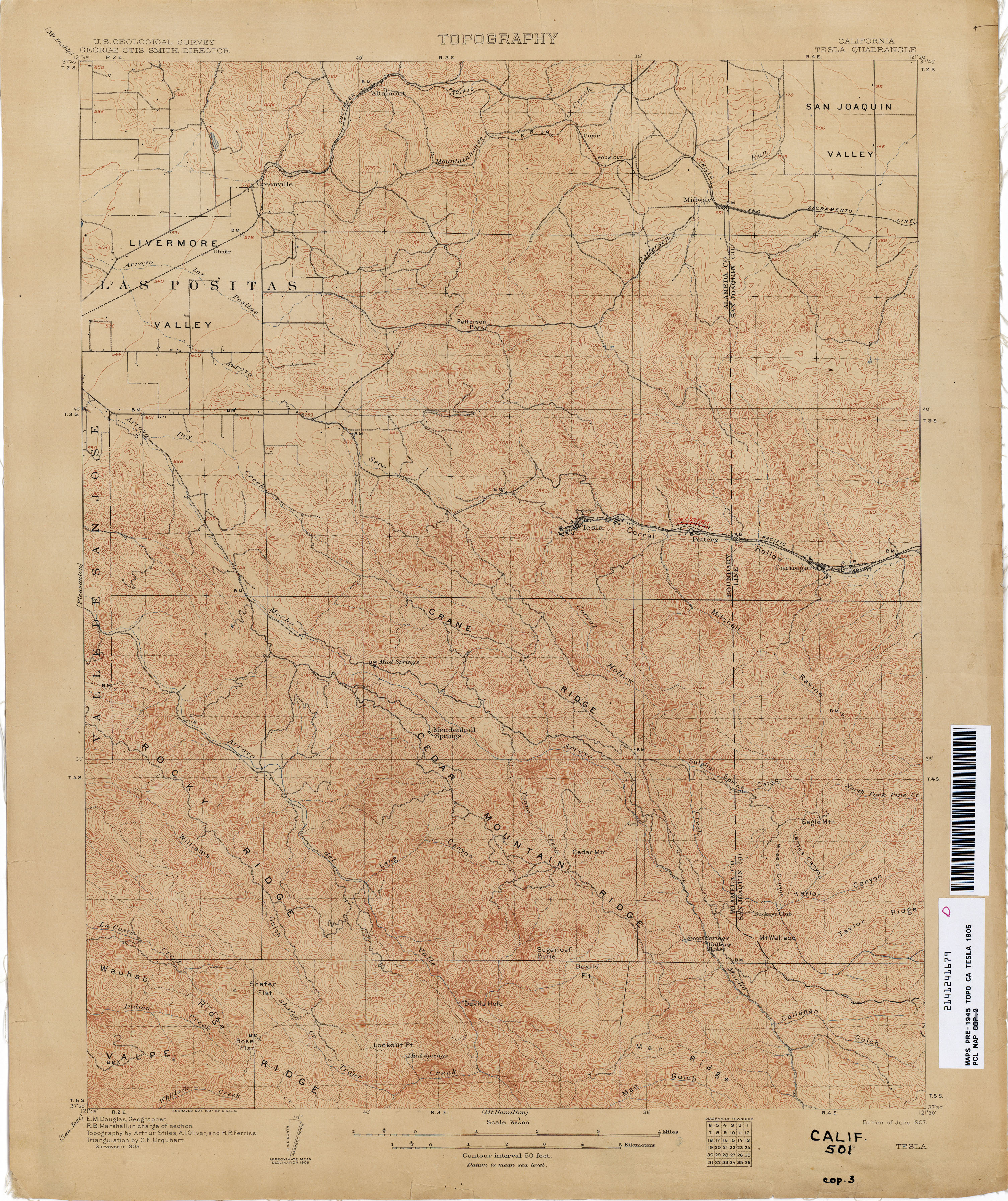
- Tesla 1905 1:62,500 from Perry–Castañeda Library, Map Collection, California Topographic Maps Topographic Map shows the extent and location of the buildings of the towns in the Corral Hollow before the flood.
Municipalities and communities of Alameda County, California, United States | ||
|---|---|---|
| Cities |  | |
| Census-designated places | ||
| Unincorporated communities | ||
| Annexed communities | ||
| Former townships | ||
| Former communities | ||
Municipalities and communities of San Joaquin County, California, United States | ||
|---|---|---|
| Cities |  | |
| Census-designated places | ||
| Unincorporated communities | ||
| Ghost towns | ||
- Former settlements in Alameda County, California
- Former settlements in San Joaquin County, California
- Diablo Range
- San Joaquin Valley
- Former populated places in California
- Populated places established in 1850
- El Camino Viejo
- Valleys of San Joaquin County, California
- Valleys of Alameda County, California
- Valleys of California